GEOTECHNICALENGINEERING1
STOCKTON
HomeGeophysicsElectrical resistivity / VES (Vertical Electrical Sounding)

Electrical Resistivity Surveys & VES for Geotechnical Projects in Stockton

Geotechnical engineering with regional judgment.

LEARN MORE

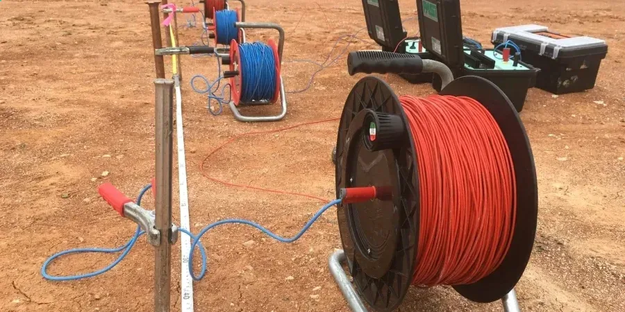
The deep alluvial soils of Stockton’s Central Valley basin, shaped by centuries of sediment deposition from the San Joaquin River delta, present a unique subsurface puzzle. High seasonal water tables and pockets of saline groundwater create a heterogeneous environment where mechanical borings alone often miss critical lateral variations. For an engineering geologist working in the industrial districts near the Port of Stockton, the question is not just what lies beneath a single drill point, but how layer continuity, moisture content, and dissolved salts change across the parcel. Electrical resistivity and vertical electrical sounding (VES) address this directly, using induced current to map stratigraphy, identify clay lenses, and delineate contaminant plumes before a single backhoe arrives on site. Integrating this non-invasive data with targeted CPT testing gives us a continuous profile of material behavior, bridging the gap between geophysical interpretation and direct cone resistance readings.

In deltaic soils like Stockton’s, a 20 ohm-m resistivity drop across a site boundary often signals the difference between a stable fill layer and compressible bay mud requiring engineered mitigation.

Our service areas

How we work

The Port of Stockton’s expansion zones, where silty clays grade into loose sands over depths of 50 feet or more, exemplify the value of resistivity profiling. On a recent warehouse foundation project east of the deep-water channel, initial VES soundings revealed a dramatic drop in apparent resistivity at 18 feet — a telltale signature of brackish pore water migrating through a permeable sand stringer. This lens was invisible to sparse soil borings alone. Our field crew deployed a Wenner array with electrode spacings extending to 200 feet, following ASTM D6431 guidelines for dipole-dipole profiling, and correlated the low-resistivity zone with a potential settlement differential under the proposed mat foundation. The subsequent design combined over-excavation of the affected layer with a reinforced granular pad, avoiding a costly pile solution. For projects where freshwater aquifers are a concern, resistivity data also inform in-situ permeability testing programs by identifying the most conductive pathways for water flow within the sedimentary sequence.
Electrical Resistivity Surveys & VES for Geotechnical Projects in Stockton
Technical reference — Stockton

Local geotechnical context

Under ASCE 7 Section 11.8 and the California Building Code, site classification for seismic design requires accurate shear wave velocity profiles down to 100 feet. In Stockton’s flood-prone basin, where groundwater can rise to within 3 feet of the surface during wet winters, misidentifying a saturated silt as a stable clay — or vice versa — has direct consequences for liquefaction triggering analysis. Standard penetration tests provide data at discrete intervals, but resistivity imaging reveals the extent of saturated zones across the full site, flagging areas where pore pressure buildup during a San Joaquin Fault event could induce lateral spreading. Our resistivity cross-sections, calibrated against SPT drilling logs, give the geotechnical engineer the spatial context needed to refine the Factor of Safety against liquefaction in each zone, rather than applying a blanket assumption across a 5-acre parcel.

Need a geotechnical assessment?

Reply within 24h.

Email: info@geotechnicalengineering1.com

Regulatory framework

ASTM D6431-18: Standard Guide for Using the Direct Current Resistivity Method for Subsurface Site Characterization, ASCE 7-22 Chapter 11: Seismic Design Criteria — Site Classification Requirements, 2022 California Building Code (CBC) — Title 24, Part 2, Section 1803 Geotechnical Investigations

Technical parameters

ParameterTypical value
Array typeWenner, Schlumberger, Dipole-dipole
Max. investigation depth (Wenner)60 to 80 ft with 200-ft spreads
Apparent resistivity range0.5 ohm-m (saline clays) to 200+ ohm-m (dry sands)
Typical profile length400 to 1,200 linear feet per survey line
Data smoothingSolid inversion with RMS error < 5%
Correlation standardASTM D6431-18, linked to boring logs per ASCE 7
Output2D resistivity cross-sections, iso-resistivity maps, VES sounding curves

Frequently asked questions

How much does an electrical resistivity survey cost for a typical Stockton commercial lot?

For a standard 1- to 2-acre parcel, a 2D resistivity survey with multiple profile lines and VES soundings in Stockton typically ranges from US$700 to US$1,180, depending on the electrode array length, depth of investigation required, and site accessibility. We provide a firm quote after reviewing your plot plan and geotechnical objectives.

Can resistivity differentiate between clean sand and clay in Stockton’s alluvial soils?

Yes, and it is one of the primary applications here. Clean, dry sands typically exhibit high resistivity above 100 ohm-m, while saturated clays and silts register below 15 ohm-m. However, pore water chemistry matters greatly in Stockton — brackish water in sands can mimic the electrical signature of clay. We always calibrate resistivity profiles with at least one boring to confirm the lithology, following the correlation protocols in ASTM D6431.

What electrode spacing do you use for a VES sounding reaching 60 feet depth?

To reach an investigation depth of approximately 60 feet with a Wenner array, we extend current electrode spacings (AB/2) up to 200 feet. The exact maximum spacing is determined on site based on the target depth and the background noise level, but a Schlumberger array is often preferred for deeper VES soundings because it offers better depth resolution with less cable movement.

How does resistivity data support liquefaction analysis under Stockton’s building code?

Resistivity sections map the lateral continuity of saturated, loose sand layers that pose a liquefaction risk under ASCE 7 ground motions. By identifying where these layers pinch out or transition to clay, the engineer can avoid applying a conservative ‘worst-case’ profile to the entire site. The CBC requires subsurface characterization sufficient to define site class; resistivity provides the spatial coverage that justifies zoning the site into areas with different liquefaction factors of safety.

Location and service area

We serve projects in Stockton and surrounding areas.

View larger map